


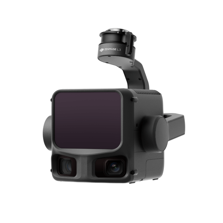
On October 4, DJI Technology Co., Ltd. (hereinafter referred to as "DJI") officially released its first long-range, high-precision aerial survey lidar system, Zenmuse L3.
Since 2016, DJI has been developing core components for its LiDAR system. In 2019, it pioneered the integration of LiDAR with drones, leveraging its strengths in the drone field to iterate its "Zenmuse" series of aerial survey LiDAR to its third generation. The release of the Zenmuse L3 marks a crucial breakthrough for DJI in the field of long-range, high-precision aerial survey LiDAR, representing a significant step towards the high-end aerial survey LiDAR market.
Five Key Technological Advantages
The Zenmuse L3 integrates four core components: a 1535nm long-range LiDAR, dual 100MP visible light cameras, a high-precision pose system, and a three-axis gimbal. This integration achieves a significant performance boost within a compact size. Particularly in terms of work efficiency, when paired with the DJI Matrice 400, it can achieve 10 square kilometers of coverage in a single sortie at an altitude of 300 meters, with a daily operating area reaching 100 square kilometers.
As a new generation of airborne lidar equipment, the Zenmuse L3, with its 1535nm long-range lidar at its core, boasts technological advantages such as long range, wide coverage, small spot size, high frequency, and multiple echoes, achieving a comprehensive breakthrough in performance and efficiency.
Its core highlight lies in the significant leap in long-range capability. Under conditions of 100 kHz frequency and 100 klx ambient light intensity, it achieves a range of up to 950 meters against targets with 10% reflectivity, with a typical operating altitude of 300 to 500 meters. Against targets with 80% reflectivity, its maximum range can be further extended to 2000 meters. Simultaneously, the Zenmuse L3's frequency can be flexibly adjusted, precisely adapting to different transmission powers and operating modes, balancing long-range detection with scene adaptability.
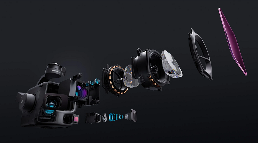
In addition to its long-range advantage, the Zenmuse L3 also excels in detail reproduction and data accuracy. The Zenmuse L3 laser has a divergence angle of only 0.25 mrad (1/e²), and its spot size at the same distance is approximately one-fifth that of the Zenmuse L2, enabling clear identification of small targets such as power lines and tree branches. Simultaneously, its enhanced penetration significantly increases the number of ground points acquired in forest understory, achieving high-precision reconstruction of complex terrain and dense structures.
Furthermore, the Zenmuse L3's maximum laser pulse emission frequency reaches 2 million points/second, and it supports up to 16 echoes, accurately reconstructing spatial information of ground features. It adjusts point cloud density and penetration capability according to different operational scenarios to meet diverse needs in high-precision mapping or complex environments.
The Zenmuse L3 has also undergone optimization and upgrades in its scanning modes. In addition to the linear and non-linear repeating scans, a new cross-shaped repeating scan mode has been added. Through multi-emission angle design, penetration is enhanced, making it better suited for traditionally challenging aerial surveying scenarios such as forests and densely built-up areas, reducing data acquisition blind spots.
In terms of visible light camera upgrades, the Zenmuse L3 features a world-first dual 100-megapixel visible light camera system, employing a 4/3 CMOS sensor and mechanical shutter, supporting pixel binning up to 25 megapixels. Simultaneously, paired with a high-precision pose system and a three-axis gimbal, it delivers efficient 3D data acquisition during cruise operations. Furthermore, its lateral field of view has been increased to 107°, requiring only a 20% lateral laser overlap rate to complete the acquisition of both Digital Orthophoto Maps (DOM) and Digital Elevation Models (DEM) in a single operation.
Thanks to the hardware upgrades, the Zenmuse L3's line-following capabilities are significantly enhanced, supporting line-following operations up to 130 meters. In most scenarios, it can acquire complete power line data in a single operation without detours or crossings, making it widely applicable in fields such as power line inspection, forestry surveys, engineering construction, emergency rescue, cultural heritage protection, and railway surveying.
In addition, the Zenmuse L3 leverages DJI's full-stack self-developed hardware and software ecosystem to provide a one-stop end-to-end solution from data acquisition and processing to application. Paired with DJI Terra and DJI Motion platforms, it boasts the capability to output various types of results. Compared to traditional multi-platform operation processes, this solution significantly lowers the user threshold, helping various industries efficiently complete surveying and mapping tasks.
Expanding to More Application Scenarios
In fact, DJI's technological strength in the LiDAR field has already been proven in the automotive sector. DJI's Livox Horizon series, with its advantages of low cost and high reliability, is used in mass-produced models of automakers such as SAIC-GM-Wuling and XPeng Motors, driving the popularization of LiDAR from high-end vehicles to the mass market.
Now, DJI's breakthrough in long-range, high-precision aerial surveying LiDAR not only breaks the foreign technology monopoly but also accelerates the technological iteration of domestically produced aerial surveying equipment. Its high cost-effectiveness and high efficiency are expected to drive the aerial surveying industry to expand from traditional professional fields to more application scenarios, promoting the popularization and intelligent development of surveying and mapping technology.
In response, DJI spokesperson Zhang Xiaonan stated, "In the future, Zenmuse L3 will drive the penetration of high-end aerial surveying LiDAR from a few professional fields to a wider range of industries and application scenarios."